
Viral satellite imagery of U.S. military assets around Iran NOT taken by Chinese satellites: Hu Bo
Veteran satellite imagery analyst and founder of South China Sea Probing Initiative says Chinese private firm MizarVision-released photos come from U.S. and European satellites

Satellite imagery of U.S. military assets released by Chinese firm MizarVision that theoretically could be used in an attack on Iran, has caught international attention, including in Israel
Chinese intelligence firm publishes photos of US F-22s deployed at Israeli air base via Jerusalem Post
Satellite images from Chinese intel firm show 11 US F-22 fighter jets at Israeli air base via Times of Israel
While repeatedly posting satellite images on the Chinese social media platform Weibo, MizarVision does NOT identify the source of these satellite images, prompting speculation online that they may come from Chinese satellites.
The question that seems to follow is, as the South China Morning Post asked in a story this week, Is China flexing its intelligence muscle by tracking US military moves near Iran?
Dennis Wilder, a former senior American intelligence official and now professor of practice at Georgetown University, raised the unusual disclosures in a social media post.
“What is Beijing’s purpose in allowing these photos to be published? Is it trying to prove its intelligence capabilities after the failure to detect the US extraction of [Nicolas] Maduro?” he wrote on Wednesday, referring to the special military operation in January that deposed the former Venezuelan leader.
Some Chinese opinion-havers appear to have doubled down on the potential significance of MizarVision tracking. According to the SCMP story
Yue Gang, a retired Chinese colonel…said MizarVision’s “intelligence collection and analysis capabilities can supplement China’s national intelligence capacities”, representing “a beneficial exploration contributing to China’s development as an intelligence powerhouse”.
……
Military commentator and former People’s Liberation Army instructor Song Zhongping said the company’s monitoring of US military movements “demonstrates capability and is advertising”.
This approach “also symbolises the strength of a nation and an enterprise”, Song added.
……
The truth, however, is boring, according to the South China Sea Probing Initiative (SCSPI), a veteran Chinese analyst of satellite imagery who often shares analyses of U.S. military deployments in or near the South China Sea.
SCSPI tweeted
This matter cannot be attributed to China. They are not Chinese satellite imagery. Judging by the satellite ephemeris, it is not difficult to find out that most of the original images are from some American and European companies.

Hu Bo, Director of SCSPI and Research Professor and Director of the Center for Maritime Strategy Studies, Peking University (and a longtime friend of our newsletters!) tells me he is “100% sure” these recent images released by MizarVision on current US-Iran military posture originated from U.S. and European satellites, not Chinese ones.
Hu says his judgment can be confirmed by the satellite ephemeris, which SCSPI mentioned in its tweet.
A satellite image can reveal more than what it shows on the ground. With enough clues from the image content and the timestamp, analysts can estimate where the satellite was when the picture was taken. Since the orbital information for many satellites is public, that estimate can often be matched to a specific satellite.
The resolutions of the imagery released by MizarVision are another tell, and they match those of satellite imagery from U.S. and European satellites, Hu says.
When pressed by the South China Morning Post today on the exact source of its images after SCSPI spoke up on Twitter
A MizarVision representative, identified only by the surname Wang, said the company’s sources were diverse and included both Western and Chinese commercial entities. But he declined to disclose sources for specific images.
Wang called the company’s analysis “normal in commercial operations” and said it “aligns with international standards”.
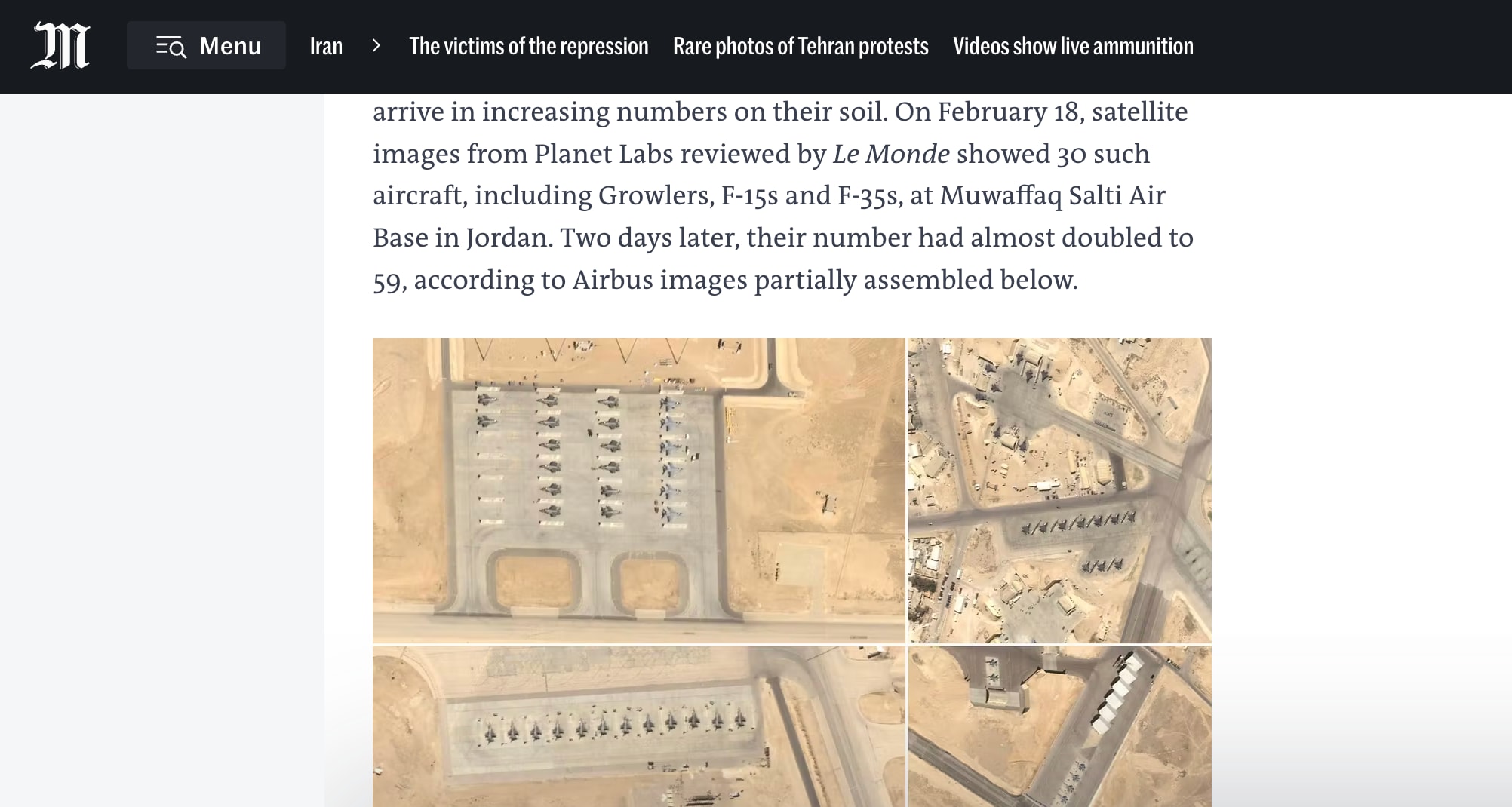
International media outlets have independently analyzed high-resolution satellite imagery of U.S. fighter planes in Jordan, demonstrating that such imagery is possible to acquire.
Le Monde, the French newspaper, last week analyzed high-resolution imagery from Planet, a U.S. Earth imaging company.
It is understood that high-resolution imagery used to identify bases—at roughly 0.3 m resolution—typically comes from the U.S. provider Vantor, formerly Maxar Intelligence, and wide-swath imagery used to detect maritime targets—at roughly 3–5 m or 10 m resolution—typically comes from the U.S. company Planet or from the European Space Agency’s Sentinel series. They are commercially available.
MizarVision, the company self-described as established in March 2021 and having completed two rounds of fundraising, says its mission is “accomplishing geospatial business intelligence through artificial intelligence, building a God’s-eye view no one can refuse.”
It would not be strange if a start-up wished to increase its visibility by taking advantage of the enormous global attention to one of the world’s biggest military crises.
When reading analyses or annotations based on commercial or open-source data, it is worth bearing in mind that the underlying data could have come from any commercial provider anywhere in the world. The fact that a Chinese company produced the annotation does not by itself mean the source data came from China. (Enditem)
Hu Bo: China Can Afford Patience at Sea

Hu Bo is Director of the South China Sea Strategic Situation Probing Initiative (SCSPI), and Research Professor & Director of the Centre for Maritime Strategy Studies, Peking University.
Hu Bo on South China Sea and U.S. military activities in 2024

Many China-focused English-language podcasts are online, mostly run by Western institutions and individuals. Some have tried hard to include Chinese mainland guests in their conversations. I applaud their efforts. For various reasons, their success is uneven.